How did Minnesota get its shape on the map?
Listen and subscribe to our podcast: Via Apple Podcasts | Spotify | Stitcher
Arguably nothing defines Minnesota more than its borders. Minnesota as we know it would not exist without them.
So it's no surprise that readers frequently submit questions on this topic to Curious Minnesota, the Star Tribune's reader-powered reporting project. They have asked about the face-like outline of the eastern border, the chimney-shaped Northwest Angle near Canada and broader topics like the question behind this story: "How did Minnesota get its shape on the map?"
The Minnesota we're used to might seem to have been inevitable. But had history gone otherwise, it could have been a wider state stretching into present-day South Dakota, with big chunk bitten out by Wisconsin. Each of the state's four borders is a separate tale.
Eastern border
The state's northeastern border in the Arrowhead region would appear to be its simplest, since it is shaped by Lake Superior. But the actual border is 54 miles from shore, where it meets the borders of Michigan and Wisconsin.
The three states share the lake due to an 1830s dispute between Michigan and Ohio over some prime agricultural land, according to historian William E. Lass, author of "Shaping the North Star State: A History of Minnesota's Boundaries." Ohio won, but as a consolation prize Michigan's borders were extended into lakes Huron, Michigan and Superior. The water beyond those boundaries later became part of Minnesota and Wisconsin.
Closer to the Twin Cities, St. Paul residents nearly became Packers fans. Before the creation of the Minnesota Territory in 1849, the Wisconsin Territory extended to the Mississippi River.
"So anyone in St. Paul or Stillwater was living in Wisconsin Territory," Lass said. When Wisconsin applied for statehood, he said, "people living in Stillwater, among other places, wanted to be left outside Wisconsin."
The two states agreed to establish the border along the St. Croix and Mississippi rivers. "The argument was that a river valley should unite, not divide," Lass said.
Southern border
The state's southern boundary has more to do with Iowa than Minnesota, Lass said. When Congress made Iowa a state in 1846, its northern border was set at 43 degrees 30 minutes north latitude.
"There were some very ambitious people that wanted a northern boundary that would put the present day Twin Cities in Iowa," Lass said. "They were aware of falls at St. Anthony and they wanted the water power."
Because rivers were important for transporting agricultural products, Congress set Iowa's northern border between the watersheds of two rivers, the Des Moines River and the Blue Earth River, Lass said.
Western border
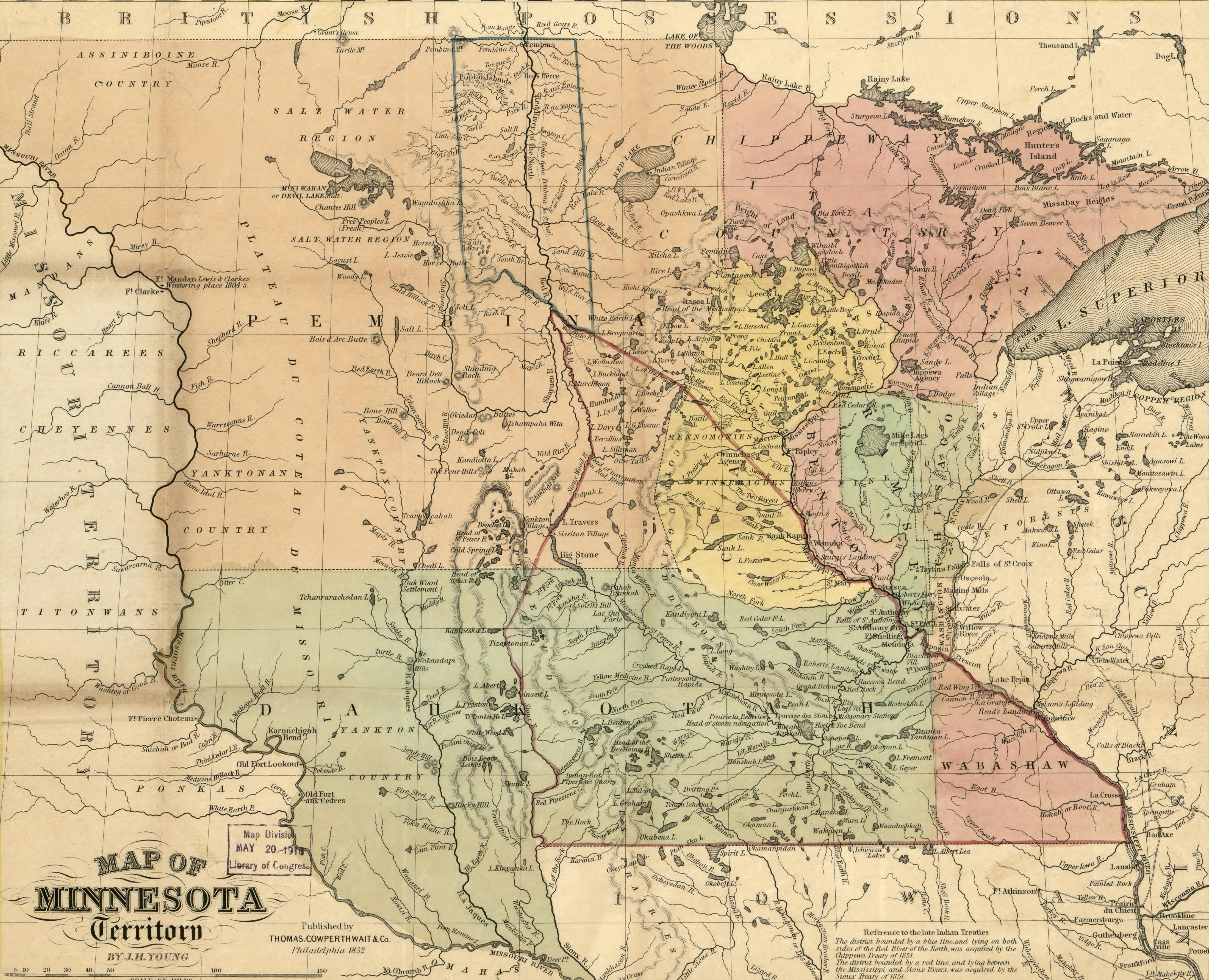
By the time Minnesota applied for statehood in 1856, Iowa and Wisconsin were already states and the Canadian border had been established. But statehood for North and South Dakota was a few decades away.
The Minnesota Territory extended at the time to the Missouri River in the Dakotas, about 200 miles west of the current border. Many Minnesotans wanted to keep the western border there and nix the North Woods, creating a more horizontal state that would maximize the agricultural land, according to Lass.
But Henry Mower Rice, a politician and businessman who later became a U.S. Senator, favored a western border much like the present one, arguing that the vertical shape would support a diverse economy based on farming, lumbering and potentially mining.
Congress sided with the influential Rice in what Lass describes as "a sort of the smoke-filled backroom type of negotiation." When Minnesota became a state in 1858, its western border was about what he'd suggested, following the Red and Bois de Sioux rivers to Lake Traverse and Big Stone Lake. From there, the border drops straight south to the Iowa border.
Northern border
Most of Minnesota's northern boundary was drawn in 1783, when the United States and Great Britain negotiated the treaty recognizing American independence.
"The treaty specified that the international boundary would run from Lake Superior by an all-water route to the northwest point of Lake of the Woods," Lass wrote in an article for the Minnesota Historical Society. "From that point it was to proceed due west to the Mississippi River." (The area beyond that was not yet part of the United States.)
Oops! That agreement with Britain was based on a 1755 map that placed the headwaters of the Mississippi north of Lake of the Woods. The Mississippi was later determined to begin 150 miles south at Lake Itasca.
During 1818 negotiations over the boundaries of the Louisiana Purchase, the countries agreed to set the western part of America's northern boundary at the 49th parallel. A line was drawn from there to a northwestern point at Lake of the Woods, meeting the existing border.
That's how Minnesota got the little chimney at its northern border, officially known as the Northwest Angle. It remains the northernmost point in the contiguous United States.
If you'd like to submit a Curious Minnesota question, fill out the form below:
Read more Curious Minnesota stories:
Why isn't Isle Royale a part of Minnesota?
Is Minnesota's tiny Lake Itasca the true source of the Mississippi River?
We call Wisconsinites cheeseheads. What do they call us?
Why is Minnesota more liberal than its neighboring states?
Did modern Minnesota roads evolve from Native American trails?
Did political shenanigans derail an effort to move Minnesota's capital from St. Paul?